Intelligence, Surveillance &
Reconnaissance
Hybrid VTOL Fixed Wing UAV
Vertical take-off and landing fixed-wing UAV designed for mapping, inspection, surveillance and rescue operations.
Jabali is the only platform of its kind featuring an integrated on-board A.I. module able to intelligently track targets, automatically detect objects, count people and vehicles and more.
Made of heavy duty advanced materials Jabali is powered by a triple redundancy, proprietary industrial-grade autopilot. Up to 8 hours flight time and 6’500 m a.s.l. at at a speed of 140km/h, with an unlimited data-link range.
Flight safety is enhanced by Jabali integrated ADS-B receiver. Such receiver provides information about position, altitude and speed of incoming manned aircraft, allowing operators to safely integrate with manned aircraft.
Jabali is an extremely versatile platform with multiple payloads, for mapping and ISR applications.
The 3-axis gyro-stabilized 30x optical zoom visible and EO/IR Thermal camera payload provides total situational awareness both day and night, and in low light conditions.
The video acquired by the UAV can be broadcasted to the cloud making it possible to view it remotely.
Lightweight and robust, with its modular design is transported by 2 people and setup for flight in minutes.
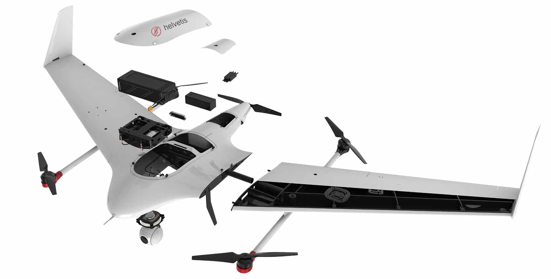
Payload. I.S.R.: 3-axis EO/IR pod – Mapping: oblique camera, PhaseOne iXM-100, Sony A7 series, LiDAR
Proprietary, highly integrated Onboard Computational Unit: triple-redundancy avionics, AI and RTK modules, data-link
Intelligent Power System LiPO battery
ADS-B receiver to locate manned aircraft
Rear propeller for fixed-wing flying
GPS receiver antenna and compass
Advanced body aerodynamics design and materials
Vertical Take-off and Landing rotor
Applications:
Security & Defence
Aerial surveillance and monitoring capabilities, streaming real-time night vision and daylight images, with unlimited range, powerful zoom and Artificial Intelligence based object tracking and recognition.
Oil & Gas Industry
Autonomous long range aerial inspection and remote monitoring for onshore & offshore assets: patrol and inspect your assets the EO/IR imaging system and the tailor made Augmented Reality pipeline inspection software.
Mining & Construction
Plug & play aerial data acquisition system: capture centimeter level GIS data and imagery of large sites to automatically create orthomosaic maps, 3D point clouds, Digital Surface Models and 3D textured mesh – taking off and landing vertically.
Survey & Mapping
Capture geo-spatial data in a fraction of the time and cost, easily reach isolated areas thanks to the long range autonomy and produce high-resolution aerial maps for cartography, land management & development, urban planning and much more.
Main Features:
Vertical Takeoff and Landing
No runway required
Jabali can be operated from confined spaces thanks to its vertical takeoff and landing abilities.
Multirotor versatility, fixed-wing flight time
Combine the advantage of multi-rotor drones' VTOL ability with the extended flight time, 70+ minutes, of our fixed-wing platform.
Powerful optical zoom & thermal night vision
30x zoom in FullHD quality
Designed for high speed flying the 3-axis pod deliver smooth FullHD video with 30 times optical zoom.
Thermal night vision and laser rangefinder
Detect any heat source such as people, animals and vehicles through Infrared Thermography imaging capabilities, add the laser range finder to measure distance to target and compute its GPS coordinates.
Artificial Intelligence
Automatic target tracking
Accurately track your target, using its onboard A.I. processor Jabali can lock any moving target and relocate temporarily hidden objects automatically thanks to onboard machine learning capabilities.
People counting & object detection
Avanced A.I. able to accurately count people and vehicles, read in real time license plates and detect objects such as boats or trucks.
Autonomous Operations
Automatic flight
Plan and execute your missions with an immersive 3D environment enabling terrain following, survey planning and automatic flight mode.
Autonomous Vessel Operations
Automatic takeoff and landing from a moving vessel, Jabali will execute the preset route following the mother ship.
Contact Us!
We’re looking forward to hear from you and discuss your specific requirements – or just have a chat about drones and innovative technologies.
-> Helvetis Campocologno (Operational Office)
Via Cantonale 29, 7744 Campocologno, Switzerland
welcome@helvetis.com
+41 44 585 32 63
-> Helvetis St. Moritz (Headquarter)
Via Stredas 2, 7500 St. Moritz, Switzerland